Old Sewer Stink Pipes – Palmerston Road and others

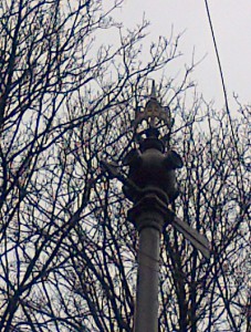
The crowned  stink pipe, Plamerston Road

The crowned stink pipe, Palmerston Road

About 10 years ago. Cllr. Hamish Pollock asked Thames Water to redecorate their stink pipes that are all over the older parts of the central Carshalton area, usually at the ends of cul-de-sacs and long roads. Most were then redecorated.

These include: Palmerston Road (as pictured), Carshalton Road by the railway bridge, Cator Road near junction with Talbot Road, Lavender Road (near junction with Bernard Road), Meadow Road/Westmead Road junction, Rotherfield Road (southern end opposite Talbot Road), Grosvenor Avenue (west end), Weihurst Gardens, and there are at least two examples in Stanley Park Road and so on. Palmerston Road probably has the best example of the intact decorative pipe crown and “weathervane” painted in black. Many other pipes are painted in “lincoln green”.


LIB DEMS HOLD KEY BY-ELECTIONS

Despite a very negative national press recently, the Liberal Democrats have held seats last week at Eastleigh, Hampshire, in a parliamentary by-election (where the nearest rivals were the UK Independence Party, and the Conservatives were third) and a council by-election in Berrylands, Kingston (where the Lib Dems beat off a strong Conservative challenge). The Eastleigh seat was formerly held by Chris Huhne, once a contender for the leadership of the Liberal Democrats. The new Lib Dem MP for Eastleigh is Mike Thornton.

The top five candidates

  • Mike Thornton (Liberal Democrat) 13,342
  • Diane James (UKIP) 11,571
  • Maria Hutchings (Conservative) 10,559
  • John O’Farrell (Labour) 4,088
  • Danny Stupple (Independent) 768

Lib Dem Mr Thornton, who has been a parish and borough councillor since 2007, said: “The people of Eastleigh recognise that the Liberal Democrats have always had a superb record of delivery, we’ve always listened to what people want, and we always make sure that we do a good job.”

The Ministry of Guesswork: How long for Sutton residents to get up to St. George’s Hospital in Tooting?!

bsbvlogo_large-W480[1]

Carshalton Central ward Cllr. Alan Salter whose accountancy training means that he is good with figures says: “There has been quite a debate recently between some local Lib Dem councillors on Sutton Council, including Cllr. Mary Burstow (who represents Cheam ward), and the NHS’s BSBV team over quite how long it takes to get to St. George’s Hospital in Tooting (proposed by BSBV as the hospital for the re-establishment of vital health services for all Sutton residents) from say a central part of the London Borough of Sutton.”

It has been established that they calculate travel times for car users, using the magic of Satellite Navigation.  This what “Tom Tom” uses to calculate journey times.

Cllr. Jill Whitehead says: “As Satnav works on average journey times, it can be a little misleading.  The BSBV team tell me the data which BSBV uses is split for peak and off peak times.  They believe it only takes an average of 13 minutes at its lowest to travel to St Georges, an average of 19 minutes and the highest travel time was 29 minutes. We would say that was much closer to the true travel time.”

Cllr. Hamish Pollock whose late wife Josephine was treated at St. George’s Hospital for some time in late 2006/7 says: “However it does not include how long it takes to park the car once you get to St George’s Hospital which has a substantial car park but it can takes ages to find an actual car parking space!!”

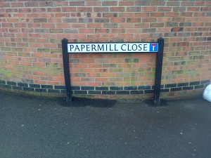
Papermill Close off Mill Lane gets two new road nameplates

The two original road name plates (from the 1990s) at the entrance to Papermill Close off Mill Lane had become rather worn away and have been replaced in recent months by Sutton Council following request by the local councillors that they be either repainted/repaired or replaced (whichever was the most economic option).

One of two of the New Road Name Plates for Papermill Close

One of two of the New Road Name Plates for Papermill Close

Latest on Carshalton High Street Shops

   Cllr. Jill Whitehead who is chairwoman of the Council’s Environment & Neighbourhoods Committee, says: “There has been a fair bit of speculation recently about the possibility of a 3rd supermarket in Carshalton High Street on the north side next door to Park Lane Pharmacy.  We understand that the rumours are referring to what are known officially as Units A, B and C of Beacon Grove (formerly a dry-cleaners’ shop, a greengrocer’s shop and a butcher’s shop respectively).

    Cllr. Hamish Pollock, a member of the council’s Planning or Development Control Committee says: “As we went to press as it were with this web site bulletin, no planning application has yet been received by Sutton Council from any supermarket chain (or their agents) in relation to these properties. Council planning officers tell us that they are not aware of any other proposals. However, as the last use of these properties was retail, planning permission would not be needed for a change of use to another retail use such as a supermarket. It is our understanding that two of the three empty units are possibly to be combined to become a cafeteria/restaurant and the third would become a new greengrocer’s shop.  Planning permission would only be needed if they were proposing to change the shop fronts, and advertisement consent would probably be needed for any signage they wanted. 

   Cllr. Alan Salter says: “It should be pointed out that having a second supermarket in Carshalton High Street in the form of Sainsbury’s (despite the misgivings of many local residents) seems to have encouraged foot fall in the High Street and it is a great credit to the local traders that the vast majority of shops are surviving this recession, thus far.  The local supermarkets of course provide much needed local jobs, especially for younger and older people in these difficult times. Nearby Wallington also has a growing number of supermarkets in the form of Sainsbury’s, Tesco, Lidl, the new store by the station approach and a 5th store at Canon Court (Sainsbury’s) near Wallington Station is being constructed as we went to press.

The Old Forge, Carshalton High Street – Update

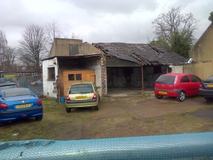
The old Forge on the north side of Carshalton High Street within the Conservation Area continues to languish in a rather unloved state – see photo taken on 1st March 2013. Planning enforcement type officers from the council are continuing to keep an eye on this structure alongside some keen-eyed local residents and councillors, as the building seems to have very slowly deteriorated.

The Old Forge, Carshalton High Street

The Old Forge, Carshalton High Street

Planning permission for restoration which was granted by Sutton Council some months ago for a car repair workshop etc. has yet to be implemented by the developer/owner, alas.

For a quick review of the changes just please click on High Street, Carshalton on the side panel of this web site.


Poets’ Estate: 40-46 Coleridge Avenue, Sutton – One Year On

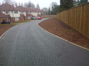
40-46 Coleridge Avenue

40-46 Coleridge Avenue

This photo of the one-year old development was taken by Cllr. Hamish Pollock on 26th February 2013.

Four houses were built in the ground of one former detached house (the original no. 40 Coleridge Avenue built by “Edser & Brown” – a typical “cottage-style detached house” in the 1920s period) at the junction of Coleridge Avenue with Shirley Avenue.  The fence on the right hand side of the photo is an acoustic fence designed to reduce the adverse affect of noise and disturbance on the occupants at no. 38 Coleridge Avenue behind.

Hamish worked with the then fellow councillors to support numerous local residents’ when they objected to these houses being given planning permission a few years’ ago.

We hope the planting to the enormous flower beds will be carried out soon….and we have asked planning officers to look into the matter as the houses have been occupied now for some time. 

More in a future posting….


Public Rights of Way: Bridle Way Footpath, off Woodstock Road

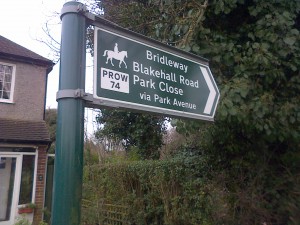
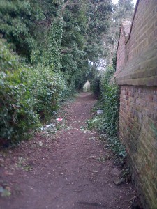
One of Carshalton’s many hidden historic treasures is the Bridle Way Footpath.

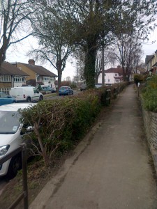
The footpath starts at the green space off Woodstock Road and which runs between Woodstock Road, Park Avenue and Park Close/Blakehall Road running down the back of the houses in Grosvenor Avenue and Ashcombe Road. Here are a few pictures of its current state.

IMG-20130223-00541

View of the path behind Woodstock Road houses

View of the path behind Woodstock Road houses

Shorts Road, Temporary Bollards pending installation of new Yellow Lines by St. Philomena’s School wall

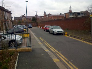
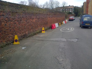
Some temporary bollards have been installed on the east side of Shorts Road by St. Philomena’s School wall by the Council as requested by local councillors Alan Salter, Jill Whitehead and Hamish Pollock at the recent meeting of the Council’s Carshalton & Clockhouse Local Committee (12th February). 

This followed problems of blocking of the road by some instances of inconsiderate parking exacerbated since the occupation of the new flats and the new nursery at the corner of Shorts Road and Carshalton Road (e.g. the 44 flats of “Carter House” etc.). The local committee have called on officers to implement some additional yellow lines on the east side of Shorts Road to hopefully prevent this inconsiderate parking.  More in a future posting….

Shorts Road looking northwards toward the wall by St. Philomena's School

Shorts Road looking northwards toward the wall by St. Philomena’s School

Shorts Road looking south towards St. Philomena's School wall

Shorts Road looking south towards St. Philomena’s School wall